|
Hold on While Loading Virtual Maps and routing ride # BR-400k | |||||||||||
|
|
Comment/Story/Advice: 2009-03-08 19:41:14 Shai
from Encino, CA:
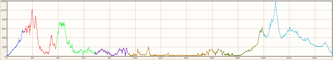
The accum elevation on the Garmin was showing 9000, but I have to say that the Edge 705 was acting up all day. DO NOT EVER use a gpx file as a navigation route; it will mess you up! the Edge 705 will try to reroute you and ignore the actual route. I ended up with many small U turn and extra miles in this all ready long 250+ miles ride. The Weather was very good but on the Cold side at night. I put the time on each photo so you can get the idea of a full day ride: from 6:30AM to 1:00AM 2009-03-09 21:20:14 Dana Lieberman
from LA (san fernando valley), CA:
Same experience with the Garmin...of course, I beamed you the route, so it was actually my fault! "On the cold side" is about the understatement of the year. That's like saying it rained a little bit on the 300K... Great ride, Shai...I spent all day trying to catch you... Post a Comment for ride #BR-400k; Level 5; 251 miles
| ||||||||||||


