|
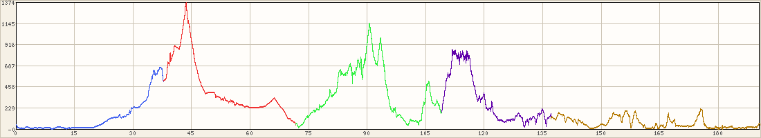
Hold on While Loading Virtual Maps and routing ride # BR-300k | ||||||||
|
|
Comment/Story/Advice: 2009-02-08 11:33:54 Shai
from Encino, CA:
Feb 7, 2009 was a rainy day, and the route was changed alot so the map/route above is not the corrent one. For the most part the route was just rearanged. We started with the climb arround lake Casitas; to Montecito. All that part of the ride was very wet - rain all the time; later in the ride we had very small amount to none of rain. Continue to El sapitan beach, and back south pass Ventura & Port Hueneme to Moorpark. and complete the route (via Grimes Cyn) back to Ventura. The 190miles route took long time due to the weather and long stops. I think most riders finished after 11:00PM, and 12:00AM (remember that we astarted at 6:40AM)! 2009-02-13 21:10:52
from LA (san fernando valley), CA:
I think Best Western sold out of shower caps that day! It's definitely not the look you are going to see at the Grammy's, but hey, it kept us dry in the morning and warm at night! Shai, maybe we will actually ride together on the 400K. I'm going to sabotage your lights just so I can keep up with you. 2009-02-13 21:11:28
from LA (san fernando valley), CA:
That last comment was from Dana... Post a Comment for ride #BR-300k; Level 5; 188 miles
| ||||||||||||


