Hold on While Loading Virtual Maps and routing ride # 310 | |||||
|
( ! ) Warning: imagepng(/var/www/virtual/shprung.com/htdocs/sfvbc//img/elev/310.png): Failed to open stream: Permission denied in /var/www/virtual/shprung.com/htdocs/sfvbc/index.class.inc on line 132 | ||||
---|---|---|---|---|
Call Stack | ||||
# | Time | Memory | Function | Location |
1 | 0.0001 | 360976 | {main}( ) | .../index.php:0 |
2 | 0.0011 | 405960 | show_html( ) | .../index.php:73 |
3 | 0.0029 | 470248 | Elev->png( $ride = '310' ) | .../index.php:365 |
4 | 0.0057 | 470864 | imagepng( $image = class GdImage { }, $file = '/var/www/virtual/shprung.com/htdocs/sfvbc//img/elev/310.png' ) | .../index.class.inc:132 |
Comment/Story/Advice: 2007-02-07 16:25:59 Shai
from Encino, CA:
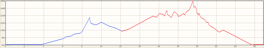
Note a small mistake in the PDF file. After 5th street you need to turn Right on Maclay Ave and not Left. And, I think this one should be level 2 and not level 1 because the two not-so-short clims (Laurel Canyon, and Sesnon Blvd) 2007-04-06 20:44:34 Shai
from Encino, CA:
The small mistake was fixed. It now say (R) - Maclay. Post a Comment for ride #310; Level 1; 26.4 miles
|